
The Irish Bomfords
The following article is reproduced
with permission from
Empire Survey Review Volume 14, No 107, pages 204-213.
Copyright © Empire Survey Review 1958
THE SURVEY OF SOUTH GEORGIA
Capt. A. G. Bomford, M.A., A.R.I.C.S., R.E. and W. S. B. Paterson, M.A.
INTRODUCTION
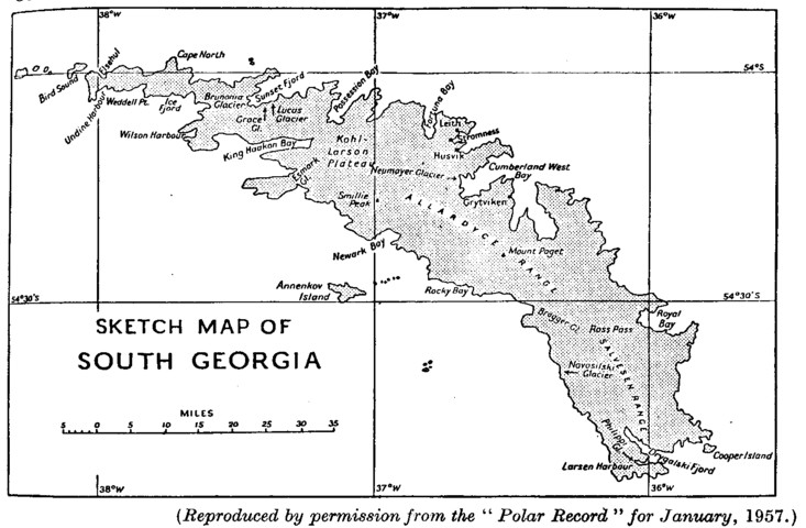
South Georgia is an island in the South Atlantic, 900 miles E.S.E. of the Falklands, of which it is a Dependency. It is 110 miles long, seldom over 20 miles wide, has a deeply indented coast, and is very mountainous. Mount Paget rises to 9625 ft., and 23 peaks exceed 6000 ft. Although the island lies in the equivalent latitude to Carlisle, the snow line is around 1000 ft and many glaciers flow into the sea.
The island may have been sighted in 1502 and 1675, but its position was not certain until Captain Cook landed to take formal possession in 1775. A member of his crew described it as "of less value than the smallest farmstead in England". Since 1904, however, it has been a centre for the whaling industry. Three companies now operate factories, fairly close together on the N.E. coast. Apart from the small administrative colony, these form the entire population, amounting to about 2000 people in summer. The surrounding seas are much frequented by whalers, but the interior of the island is uninhabitable, and until 1951 was unexplored. The Admiralty Chart [No 3596, published 1931, price 7s.] was made from running surveys at sea. It shows many rocks and soundings, but their position is as indefinite as that of the coast. Nearly every year since the war, a ship has been lost or badly damaged.
No one was prepared to survey the island, however, until Duncan Carse on his own initiative led an expedition inland during the southern summer of 1951-52. This expedition, six men strong, achieved a good deal. They triangulated and mapped about 40 % of the island, centred around the inhabited area, and heighted the main peaks. Some of their work has been improved, but about 20% of the final map remains as surveyed by them [For note on work recently completed by Carse see postscript at the end of the next instalment]. A second expedition in 1953-54 was less successful. Initially only four men strong, it was reduced to three and then to two; but two important journeys were made, and much of their work has proved useful.
Carse planned a third expedition for the summer of 1955-56, to complete the map. He chose a larger party of eight, all of whom were mountaineers. The authors of this article were his two surveyors, and we shall describe the problems we met in Surveying the island, and the methods we used to overcome them.
TRAVELLING CONDITIONS
The climate of South Georgia is cold and damp. The daily summer temperature generally ranges between 20° and 40°F., which, while not cold by polar standards, is unpleasant. Mists and high winds predominate. With the bad weather, and fairly long distances to travel, our party had to be away from base, completely self-contained, for a month or two at a time. We adopted polar techniques of travelling and living: kept weights to a minimum; ate typical polar rations (28 oz. per man per day); slept on air mattresses in small two-man tents; and travelled mostly on ski. We man-hauled our equipment on sledges up the glaciers, most of which were linked by easy cols. We did not often have to backpack; but we were prepared to carry our sledges and relay our loads, and were able to surmount very rugged country.
 [Click on image for enlargement]
Fig. 1.
JOURNEYS
The expedition arrived in South Georgia on 25th September, 1955. Ten days were spent unpacking and organizing our base, and thereafter we were in the field for six months, apart from three brief spells in base between journeys.
On our first 60-day journey, we hoped to link the central area around the whaling stations, surveyed on the first expedition, to the area in the west where a few observations had been made in 1953-54.
We started off through the mapped area, and were able to grow accustomed to sledging, skiing and the routine of camp life without having to worry much about surveying. On the 10th day we were in a position to begin work, and were unexpectedly blessed with five days of perfect weather. We made good use of it. We were camped in the centre of a circular plateau about eight miles in diameter; we measured an L-shaped base, took sun-azimuths and an astro fix at the corner, and observed from the terminals to fix everything within view. We observed at four other survey stations, one of which had been intersected in 1952, soundly extended the base, fixed four other peaks which had been co-ordinated previously, and obtained first rays into a large area of new country. In order to reconnoitre a route for the fourth journey on the far side of the watershed, two peaks of 5637 and 6367 ft. in the main range were climbed (the latter the highest point then attained on the island), and compass controlled panoramas were drawn and photographed from the summits. In the end we were thankful when the weather began to break up. One surveyor was completely snow-blind and in great pain, due to the impossibility of wearing goggles when observing, and many of us were stiff, blistered or sore-eyed. But the survey was off to a flying start.
In the next 10 days we were able to move camp four times and to occupy six more survey stations. Then the normal bad weather set in again, and we sat in Camp XII for eight days waiting for the wind to die down and the cloud to lift. We computed steadily, plotted the trigs. and started drawing.
The journey lasted its full 60 days. Towards the end we separated into two parties of four in order to cover more ground. Both parties measured a base. On the 52nd day, we joined up again, and sledged back to a whaling station, where we were most hospitably received.
The second journey completed the survey of the western end of the island. Here few peaks exceed 3000 ft., so there are few big glaciers, and sledging is seldom possible. We split into two parties, and landed in different places, to reduce the amount of backpacking. One party measured a base in the far west of the island, the other observed an astro fix, and the triangulation was carried through to the farthest off-lying rock. Both parties finished their surveying within three weeks of landing, but it was another 10 days before either could attract the attention of a whale-catcher to get a lift home. Fires of paraffin and tussock grass proved an ineffective signal, but a helio made from an unused shaving mirror was seen the first time there was any sun.
The third journey lasted a month, in hitherto untravelled country in the south-east of the island. Theodolite observations were made from a 7205 ft. peak, which remains the highest point so far climbed in South Georgia. All went well until the 20th day, when we encountered an eight day blizzard, and afterwards had time to snatch only two more survey stations before our pre-arranged rendezvous with a sealer. The triangulation was extended to the end of the island, but we were unable to close on a base or an astro, and a strip of coast at the end of the island remained unsurveyed.
We spent only four days in base, as the season was now well advanced, and the weather worsening. We hoped to survey the central sector on the southern side, but a landing from the sea on the south coast could not be arranged, and we had much arduous sledging before we took our first survey station overlooking the new ground. The weather grew worse rapidly during the day, and five of the party who had been moving camp lost themselves in the mist. They had gone out only for a few moments to try to guide the returning survey party back to the new camp, and were ill equipped for a night in a crevasse. The next day the weather was no better but having very little food, they decided to try to reach the nearest whaling station. The weather cleared, and they succeeded in doing so. The survey party found the tents in a brief spell of visibility, were dismayed by the absence of their follows, and as soon as the weather cleared sledged back towards the whaling station with as much kit as they could haul. They were met a few miles out of the station by a helicopter from one of the factory ships, and there was much relief all round. Little time remained, but a three-man party returned up the glacier, observed at a second survey station overlooking the new ground, and recovered more of the kit. Thirteen two-ray fixes whose heights checked satisfactorily were obtained in the new area, which, together with the panoramas made on the first journey and some good photographs from the sea have enabled us to fill the area with reasonable mapping.
We left the island on 1st April, 1956, and arrived in the United Kingdom on 6th May.
SURVEY PROBLEMS
The common problem, yours, mine, every one's,
Is not to fancy what were fair in life
Provided it could be, - but finding first
What may be, then find how to make it fair
Up to our means - a very different thing!Robert Browning: Bishop Blougram's Apology.
The weather proved the greatest obstacle to survey work, the higher peaks being out of cloud for perhaps eight hours a week on the average; and conditions changed so rapidly that parties had often to find their way back to camp in thick mist from a half-finished survey station. Although the expedition consisted largely of skilled climbers, the shortage of good weather was so acute that we never tackled difficult hills deliberately. But we were able to judge which peaks would be reached most rapidly from camp, and, if unforeseen difficulties arose on the ascent, could overcome them with the minimum of delay. Mountaineering considerations played a large part in the choice of survey stations.
A survey party consisted of at least three men, and we tried to send out two parties whenever the weather cleared; but in new country men had often to be spared to reconnoitre the forward sledge route. The knowledge of the country gained by the leader on his previous visits saved much valuable time.
The time factor, and the inaccessibility of many of the peaks, ruled out cairn building except at occupied stations; so that although many peaks were sharp, and made satisfactory trig points, the transmission of scale and azimuth through the triangulation was likely to be weak. An error of 10 metres in the position of a trig point is immaterial on an exploratory survey at 1:100 000; but the scale error in the line joining two such points 10 kilometres apart is 1:1000, and the azimuth error is about 3 minutes. Unless controlled, these errors mount rapidly. We planned to observe sun azimuths whenever possible, and to measure several short bases to an accuracy of 1:1000 rather than one or two very accurate ones.
The problem of recording the topography had not been solved satisfactorily on the previous expeditions. A rapid, comprehensible, and permanent method was still required. Plane-tabling was too slow. Haphazard ground photographs are unsatisfactory, and photographs are no use until one has had access to a dark-room. A photo-theodolite had been used in 1951, but the photographs turned out badly, and the angles proved inadequate. We decided to take photographs covering the full horizon at every survey station, and also to draw accurate and detailed panoramas, and, when the main observations at a station had been completed, to take angles with the theodolite to as many points of detail as time permitted.
We carried a calculating machine, slide-rule and drawing instruments with us on our sledge journeys, and did much of the mapping when confined to our tents by bad weather. In a better climate we should have had more time for surveying and less for computing; but we found many advantages in computing and drawing as promptly as possible in the field. Difficulties frequently arose during computation, but, with the work fresh in the surveyors' minds, they could be resolved at once from memory in most cases. Six months later and 6000 miles away this might not have been so.
On the same principle, during our spells at base, the photographic panoramas were developed, and fair preliminary drafts of the maps were drawn on linen and sun-printed at the local whaling station. We thus insured against the loss of our records, and their unintelligibility. Moreover, we wished to reduce the work to be done subsequently in the United Kingdom, because only one of the two surveyors would be available, and not for very long,
DRILL AT A SURVEY STATION
On a huge hill
Cragged, and steep, Truth stands, and he that will
Reach her, about must, and about must go;John Donne: Satire III.
Given the weather, the observations at a station took about three hours of intense work, during which the party had to keep warm and in its right mind. In addition to the survey equipment (theodolite, tripod, observation books, compass, thermometer and aneroid) and the climbing gear (rope, ice-axes, crampons and torch) we had to carry a ruck-sack of sweaters and balaclavas, food and a thermos: three full loads with which to climb and ski. For observing and drawing, we wore silk gloves and woollen wristlets, which were excellent.
Most summits were of hard snow, on which it is difficult to set up rigidly. The midsummer sun in 54°S. is quite strong, and it was essential to bury the black metal feet of the tripod completely in the snow. Rounds were limited to eight stations, and closed; and the level checked between rounds. The circle was set in the magnetic meridian, so that both theodolite and compass angles could be recorded direct on the panorama. It is convenient to keep the direction of the RO constant within about 10'', so the lower plate was adjusted on relevelling. Initially a complete set of observations was taken on face left, hills being taken in the order of importance, and much attention given to the direction of approaching cloud. Generally about 32 peaks were observed. Coastal tangents and shots to important detail followed, to minutes only in horizontals, but to seconds in verticals. Then the face right angles were filled in to those hills still out of cloud; but at least two face right verticals were always taken to check the vertical index error. Speed being more important than accuracy, horizontals and verticals were usually taken at a single pointing, and one pair of face left and face right sufficed for all angles except those extending a short base. We usually built a 6 ft. cairn or snow-man before leaving.
The booker and the panorama drawer both used 9 x 9 in. graph book with stiff covers. An eight-station round fitted conveniently on a line, or, alternatively, a quadrant of panorama, each 1/10 in. square representing one degree, which is a great help both in the field and in the office. Hills were given temporary unofficial names, which were defined by an arrow on the panorama. The correct identification of the peaks was then checked at leisure in camp, and no time had to be spent on this troublesome matter in the field.
Angles to points of detail were usually recorded direct on the panorama, with an arrow to the point. This is the best system in strange country or when time is frantically short, but it leads to untidiness. In familiar country, we tried listing the angles with a descriptive name, but it takes ingenuity to think of perhaps 80 unambiguous names, and it is essential to record the names on the panorama.
Field observations were made in pencil, and all reductions in ink. The means of FL and FR were taken out on the observation sheets the same evening, without fail. Blunders in the field work were frequently found, but, when promptly detected, could be rectified surprisingly often. The observation sheets were cut out of the books, filed and indexed, and never left camp again. The reductions were checked later by the computer, but no copies were made.
COAST LINE
Because of the practical importance of accurate coastal mapping, stations overlooking the coast were selected whenever possible. Tangents were observed with the theodolite to peninsulas, the inner edges of bays, and to both sides of islets and groups of rocks. Rocks just awash were observed accurately, and those visible from two or more stations rigorously co-ordinated to check sea-level.
To fix coast
and rocks visible from only one station, we developed the technique of
"ranging", which is the inverse of trig. heights. A vertical angle from a hill
of known height to a point at sea level gives its distance. The computation is
best done on a slide rule in two stages, the first of which gives the correction
in seconds for curvature and refraction, which is:
(0.00424) x (Height in feet) x (cot observed depression)
and the second the range in feet:
(Height in feet) x (cot corrected depression).
It is very quick and easy. Horizontal angles give azimuth, and the point is
plottable.
This technique was particularly suited to South Georgia, where tides are small, and trig points over 2000 ft. high frequently overlooked the coast so that depression angles were steep, often exceeding 10°.
SUN AZIMUTHS
We observed sun azimuths by altitudes whenever possible, but this amounted to only 15 out of 62 stations. When computing we should have liked many more. With tight azimuth control, the selection of the final point on a semigraphic fix can be accurately judged by considering the quality of the various rays. Without it, accuracy degenerates rapidly.
Three is a good minimum for a set, in case a blunder is made. They can be observed in 15 minutes, and computed in 30. The observations and their reduction are well recorded in the same column (see Example 1). Five figures suffice for nearly all work, and for graphical work on a reconnaissance survey, the use of a slide rule is recommended.
EXAMPLE 1. OBSERVATIONS AND REDUCTIONS OF A SET OF THREE SUN-AZIMUTHS BY ALTITUDES
Observations in roman type. Reductions in italics.
cos A = (sin d - sin f . sin h) / (cos f . cos h)
KADE WEST. 20th December, 1955.
|
R.O.: |
Paryadin Central. Temp. 32°F. Pressure 22.20 ins. |
|||
|
G.M.T. |
|
1830 |
1836 |
1839 |
|
R.O. |
FL |
285 46 50 |
285 46 51 |
285 46 51 |
|
|
FR |
105 46 36 |
105 46 37 |
105 46 37 |
|
|
Mean |
285 46 44 |
285 46 44 |
285 46 44 |
|
Sun H |
FL |
284 20 31 |
282 57 17 |
282 34 57 |
|
|
FR |
104 40 03 |
104 01 42 |
103 03 39 |
|
|
Sum |
34 |
58 59 |
5 38 36 |
|
|
Mean |
284 30 17 |
283 29 30 |
282 49 18 |
|
Sun V |
FL |
126 12 34 |
125 17 59 |
125 02 54 |
|
|
FR |
54 32 32 |
54 58 30 |
55 37 13 |
|
|
Diff. |
71 40 02 |
70 19 29 |
69 25 41 |
|
|
Mean |
35 50 01 |
35 09 44 |
34 42 50 |
|
Refraction |
|
- 1 15 |
1 17 |
1 19 |
|
Parallax |
|
+ 7 |
7 |
7 |
|
h |
|
35 48 53 |
35 08 34 |
34 41 38 |
|
f |
|
54 05 24 |
|
|
|
d |
|
23 25 49 |
|
|
|
Cos d |
|
58 651 |
|
|
|
cos h |
|
81 091 |
81 772 |
82 221 |
|
Product |
|
41 561 |
47 960 |
48 223 |
|
sin f |
|
- 80 994 |
|
|
|
sin h |
|
58 516 |
57 562 |
56 919 |
|
sin d |
|
- 39 764 |
|
|
|
cos A |
|
16 044 |
14 299 |
13 141 |
|
A of Sun |
|
279 13 56 |
278 13 16 |
277 33 04 |
|
Included < |
|
01 16 27 |
02 17 14 |
02 57 26 |
|
Az. of R.O. |
|
280 30 23 |
280 30 30 |
280 30 30 |
|
Mean |
|
280 30 28 |
|
|
|
Convergence |
- 33 54 |
|
|
|
|
Grid Brg. |
|
279 56 34 |
|
|
Our greatest difficulty was usually the determination of a sufficiently accurate latitude for the astro triangle, and longitude for the convergence. We had to do a graphical fix on our field sheet, transfer this to the old, inaccurate but graticuled map and scale off. Subsequent analysis has shown that the origin of our field co-ordinates was sometimes 400 metres from the origin of the projection, so that even with the utmost care in the graphics, these latitudes were apt to be 12'' or so in error, affecting the azimuths by a similar amount.
The map is drawn on the Conical Orthomorphic projection. The arc-to-chord correction was for us always insignificant, but the convergence to be applied to the sun azimuths ranged up to a degree at the ends of the island, and was of course quite vital.
BASE LINES
Seven bases were measured during the season. They were simple affairs, measured with steel tapes, usually on the surface of snow-covered glaciers. They averaged 1500 ft. in length, and were measured out and back in little over an hour. Measuring out in 250-foot lengths and back in 200-foot lengths checked the number of tape lengths beyond doubt. An accuracy of 1:1000 was all that was desired, and was easily obtained except in one case where a " topographical " base (see below) was badly needed and had to be measured over a heavily crevassed and moraine-strewn glacier. The ends of the tape lengths were marked by pencil on wooden tent pegs trodden flat into the snow. Corrections were made for slope and temperature only, but we should have liked a spring balance.
 [Click on image for enlargement]
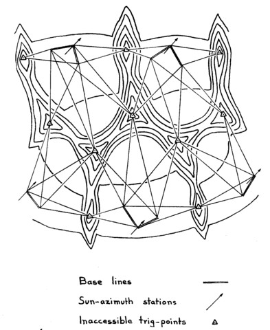
Fig. 4. Schematic diagram to illustrate a method of surveying neighbouring glacier basins separated by inaccessible ridges. The length of the base lines is exaggerated.
To control the scale of the main triangulation, bases were extended by one or two fully observed and cairned triangles. Apex angles as small as 3° were acceptable, provided they too were accurate to 1:1000, i.e. about 10''. The closure of the triangle provided the necessary check.
Short bases are also an economical way of filling in topography. Theodolite observation from the ends of a base, or preferably from three stations on an L-shaped base, can be computed on a slide rule to give the distance and height of every point observed with an accuracy approaching 1:1000. With an L-shaped base it is good practice to observe all three angles in the base triangle as well as two sides, to provide sound checks. It is also wise for the same person to observe the same points from each end of the base, as a slight misidentification in a pointing spoils the fix. But the aspect of distant points changes very little along the length of a base, and misidentification by the same observer within the hour is unlikely. The misclosure in heights is the only check against misidentification. A suitable column for the slide rule computation is shown in Example 2.
EXAMPLE 2. COMPUTATION OF DISTANCE AND HEIGHT FROM A SHORT BASE BY SLIDE RULE
|
1. To fix C |
Cake |
Nordenskjolo |
|
2. From A |
Brogger South |
Brogger South |
|
3. And B |
Scree |
Scree |
|
4. Obsd. H at A |
136 21 17 |
345 01 18 |
|
5. R.O. |
01 19 46 |
01 19 57 |
|
6. Az. Corn. (from Sun azimuth) |
6 04 36 |
06 04 47 |
|
7. Obsd. H at B |
140 59 20 |
342 14 07 |
|
8. R.O. |
284 48 45 |
284 49 14 |
|
9. Az. Corn. |
8 02 08 |
08 02 37 |
|
10. Azimuth AC (4-6) |
130 16 41 |
338 56 31 |
|
11. Azimuth BC (7-9) |
132 57 12 |
334 11 30 |
|
12. Difference (11-10) |
2 40 31 |
4 45 01 |
|
33 30 04 |
117 50 06 |
|
|
14. |
143 49 25 |
57 24 53 |
|
15. Sum = 180' (Check) |
180 00 00 |
180 00 00 |
|
16. Dist. AB |
3 632 |
3 632 |
|
17. Dist. AC (Sine Formula) |
45 900 |
36 820 |
|
18. Dist. BC |
42 920 |
38 700 |
|
19. Obsd. V at A± |
+06 38 02 |
+08 58 24 |
|
20. Refraction |
3 15 |
2 36 |
|
21. VA |
6 41 17 |
09 01 00 |
|
22. Obsd. V at B± |
+ 6 11 07 |
7 32 43 |
|
23. Refraction |
3 02 |
2 44 |
|
24. VB |
6 14 09 |
7 35 27 |
|
25. rH AC (Dist. AC tan VA) |
5385 |
5845 |
|
26. Ht A |
1823 |
1823 |
|
27. r H BC (Dist. BC tan VB) |
4685 |
5155 |
|
28. Ht. B |
2515 |
2515 |
|
29. Ht. from A (25+26) |
7208 |
7668 |
|
30. Ht. from B (27+28) |
7200 |
7670 |
|
31. Mean |
7204 |
7669 |
If a sun azimuth is taken at one base station, only one of the out-stations needs to have been previously fixed, and all the new work is plottable. This technique would be admirably suited to the survey of neighbouring glacier basins separated by inaccessible ridges - see Fig. 4.
We did not have a subtense bar, but sometimes wished we had. In a country where surface taping was less easy, a bar would probably have been worth its weight.