
The Irish Bomfords
The following
article is reproduced with permission from
Empire Survey Review Volume 14, No
108, pages 342 to 350.
Copyright © Empire Survey Review 1958
THE SURVEY OF SOUTH GEORGIA
Capt. A. G. Bomford, M.A., A.R.I.C.S., R.E. and W. S. B. Paterson, M.A.
(Concluded from No. 107, page 213)
ASTRO FIXES
We planned to take astro fixes whenever possible; first, because on the previous expeditions trig fixes had been in error by up to 400 metres, and we were in no position to assume we should do better; second, because South Georgia is a likely place for big deviations of the vertical, and it would have been interesting to see how the deviation varied on either side of the main range.
As it turned out, only four fixes were obtained during the season, and except for saying that the discrepancies between the fixes is greater than can be attributed either to the fixes themselves or to the intervening triangulation, no information about the deviation was obtained.
Position lines were the only feasible type of observations, as one could not say until dusk if the sky was going to be clear, and it was very seldom completely free from cloud. We observed four shots on to 8, 12 or 16 stars between the 2100 and 2400 local time B.B.C. pips. Time was carried over the interval on three Longines chronometer watches, and Heuer stop watches with double second hands were used for timing the stars.
The same person did all the timing and observing to try to reduce personal error. On the time signal he started a watch with each hand, and immediately compared each watch with each chronometer, getting a mean-of-two error for each chronometer, and making further comparisons if he wished. Immediately before a star was observed, after it had been found in the telescope, the observer compared one watch with all three chronometers, getting a mean-of-three error for the watch. One hand of the watch was stopped as the star crossed the line, the time read out to the booker and the hand freed. Four pointings were obtained very rapidly. At midnight, the pips were taken again on both watches, giving the new error and hence the rate of each chronometer. Thus three measures for the error of the stop watch at the instant of observation were obtained.
Whatever method is used for timing, the observations of the time signals and the comparisons of the clocks are just as vital as the altitudes of the stars, and they were recorded in the same book, not on loose sheets of paper.
The diagonal eyepiece was used, and stars observed between 50° and 70°, balanced successively in azimuth. The magnification of the diagonal eyepiece is however less than that of the straight telescope, and we consider our chief source of inaccuracy was simply uncertainty as to the precise instant that the star crossed the line. Time-altitude graphs were drawn for all stars and were considered to be worth the trouble.
[Click image for enlargement]
The southern stars were comparatively unfamiliar. We tried to identify stars from the chart, but did not persevere with the fainter ones; it was too cold. The declination of every star was computed from dh/dt by slide rule, and if it checked with the chart identification, that sufficed. Otherwise we solved for hour angle and identified the star completely. We are in no doubt that the declination check is worth while in every case. By slide rule it is very quick, and we had several misidentifications, notably Alpha Hydri from Alpha Hydrae.
For the "Star Almanac for Land Surveyors" we have nothing but praise. Every star we observed was found to be in the star list, even 213 G Puppis, which was not shown at all on our star chart. Five-figure Tables were, of course, insufficient, so we used Peters' Tables in base, but while sledging preferred the labour of machine interpolation in Chambers' Seven-Figure Tables.
For selecting the final point from the dozen or so position lines, we used a circle drawn on transparent plastic, with radius equal to the apparent vertical index error. The plots were not as precise as we had hoped, but it would be against the evidence to shift our fixes by as much as five seconds of arc.
COMPUTATIONS
Our Facit computing machine stood up to a lot of dampness and abuse on the sledge journeys without complaint. For Tables, we carried the H.M.S.O. Five‑Figure naturals [Five-Figure Tables of Natural Trigonometrical Functions prepared by H.M. Nautical Almanac Office, London, H.M.S.O., 1947. 15/- net.], tabulated to 10''. Five figures suffice for nearly all topographical work, and these excellent tables are strongly recommended. Before the war, slide rules with convenient trigonometrical scales for surveyors were made only in America. Now both British Rules Ltd. and the Danish Diwa firm make suitable rules, and ours was much used. Computations were done on paper squared in inches and fifths, which is superior to ordinary quarter-inch arithmetic paper for graphical work.
The first step in computing was to convert the observed directions, oriented by compass, into grid azimuths. The correction was obtained whenever possible from a sun azimuth; failing that, by resection, an incoming ray from a previous station being used for a first trial whenever available. When the station had been fixed, the observation sheets were inscribed like this:
|
Take the R.O. as |
180° 42' 20" |
|
For grid azimuths subtract |
7 16 48. |
The first line was required, as the R.O. reading was not exactly constant between rounds, and all the directions in a round had to be corrected mentally by a few seconds to bring the R.O. to the standard figure. The subtraction of the magnetic variation was invariably done long-hand on the computation sheets.
The trig diagrams were a mass of rays, resected points being fixed on average by seven rays, and intersected points by five. The graphs were drawn at 50 metres to the inch, and co-ordinates given to metres.
Heights were computed in feet, distances being computed by Pythagoras's Theorem, first obtaining a square root on the slide rule, and dividing this approximate root rigorously into the square by machine, as advocated by Comrie. The correction for curvature and refraction was computed by slide rule at 4''.24 per 1000 ft. Rays were not very long, and although early morning and late evening verticals were treated with reserve, we had little trouble from abnormal refraction. The four shortest rays were usually computed, and others added if the spread was great. Straight means were accepted, but an eye was kept on the results, and if rays from a station tended to give low heights, its own height would be inspected and possibly raised. Heights were recorded to the nearest foot.
We started the survey of each new area by measuring a base and an azimuth, sooner or later getting an astro fix, and computing on a local grid. Areas on different grids were fitted together by comparing the co-ordinates of points common to both, of which we usually had about eight, and shifting one grid to make the mean of the co-ordinate differences zero. This is clearly a much sounder plan than starting a new area by resecting two points from distant trigs, and accepting them as a base.
DRAWING
In the U.K. we had not been convinced that plane tabling was impracticable, and we had had the existing maps gridded and printed on enamelled zinc, and cut to fit the plane tables. Owing to the shortage of fair weather, plane tabling was in fact out of the question, and, if a suitable cover could have been made, we would have preferred a drawing board and T-square. We drew in pencil on gridded sheets of transparent astrafoil, which was impervious both to water and to repeated applications of india-rubber, and was much liked. In areas which had already been partially surveyed, we worked with the printed zincs underneath as a guide, and tried when out in the field to improve the existing form-lines by eye. But in most places, changes were too great, and we had to start from scratch.
We drew at a scale of 1:100 000. Trig points were plotted and pricked as soon as they were fixed. Spot heights were rayed in with an adjustable set-square, which even without a T-square is a much more precise and convenient tool than a protractor. Having been observed to the nearest minute, rays met precisely, unless a blunder had been made in identification or in the graphics. Points were pricked, distances scaled off with great care, and heights computed by slide rule. Tangents and ranges were plotted, and the coast and contours drawn in from the panoramas. Science here gave way to art, and much india-rubber was required until it could at least be said that the map nowhere contradicted the panoramas. We drew with a contour interval of 500 ft., which may seem large for the scale; but the country is very rugged, and except perhaps in the west where hills are lower, this interval gives a fair picture of the terrain.
We tried always to draw the map while the ground was still fresh in our minds, and aimed at finishing the drawing in base camp before setting out on the next journey. Our first draft was ready for printing six days after we returned from the first journey. It was drawn entirely from the field panoramas, but in base we had the use of a dark room, and after the later journeys we drew with both the field and the photographic panoramas before us. Before we left the island, all the survey panoramas were developed, and by the time we arrived in the U.K., our preliminary drawings were complete.
EQUIPMENT
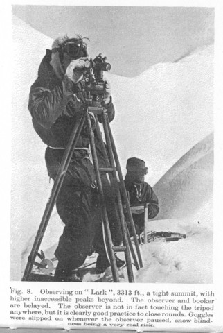
We had two Tavistock theodolites on loan from the Directorate of Colonial Surveys [Now the Directorate of Overseas Surveys], who lent us every item of surveying equipment for which we asked. One theodolite had been treated with arctic grease. It was a pleasure to use and gave no trouble throughout the season. The other was rather stiff on its bearings and in the foot screws, and was unpleasant to use in cold weather. Both suffered frequent heavy jolts when carried by inexpert ski-ers, and the vertical index used to drift, but no real trouble developed. The canvas cases were usually wet through, and the instruments themselves occasionally got wet when used in drifting snow. On two occasions they remained wet for several days, and there was some internal condensation; but it rapidly cleared, and we were never prevented from observing.
The normal wooden tripod was an awkward load to ski with; it travelled best tied vertically to a Bergen rucksack frame from which the rucksack had been removed. A rigid tripod is essential, and we are not prepared to recommend the use of a telescopic tripod without a trial. The aluminium cap shrank on to the brass tripod head in cold weather, and in the early days we often had the utmost difficulty in removing it. There is, however, an infallible remedy, involving the use of warm water, which the authors will be glad to pass on confidentially to those interested. One tripod leg broke near the top, but was repaired with a pen knife by shortening it three inches, which caused little inconvenience.
A small Kern theodolite had been lent to us, but its tripod was inadequate, and the vertical circle bubble unstable, and after two attempts we stopped using it.
Our RBZ receiver was frequently very wet, but never failed to give us the B.B.C. pips loud and clear. We never succeeded in hearing WWV, but that may have been our fault.
A 300-ft. steel tape was initially used for the bases, but it was difficult for a small party to control in a wind, and it broke. 100-ft. tapes proved slower, but satisfactory. Lacking oil, tapes were greased with butter immediately after use, but we were unable to keep them free from rust, and all returned the worse for wear.
The computing machine was carried in a corrugated cardboard cover, inside a plastic bag in a plywood ration box. Plastic bags in plywood boxes are a light and effective means of keeping small stores and papers dry. It was not necessary, nor indeed possible, to keep the boxes inside the tents.
RESULTS
During the season, we spent 140 days in the field. Surveying was possible on only 31 days; on 49 we were able to travel; and on the remainder, the weather confined us to our tents.
240 points have now been co-ordinated in South Georgia, and a similar number fixed graphically and heighted by slide rule. The semigraphic fixes of the best 170 points suggest a probable error of 5 metres relative to adjacent points, and few of the remaining 70 are likely to be in error by more than 20 metres. Over longer distances, accuracy is likely to be affected by the scale error, which we think lies between 1:500 and 1:1000. The probable error in height above sea level of any trig point fixed in the 1955-56 season is about 10 ft., with the error in spot heights possibly twice as much.
Our final co-ordinates are based on the best fit on seven astro stations, The range of the discrepancies at the astro fixes is 675 metres in easting and 1060 metres in northing. This is greater than the errors in the fixes themselves, which we do not think exceeds 5'' or about 200 metres, and is at least three times the error we are prepared to attribute to the intervening triangulation. One must beware of ascribing errors due to poor work to the deviation of the vertical, but deviations of 25'' might reasonably be expected in South Georgia, and we conclude that large deviations do in fact occur. Nevertheless, the accuracy of the latitude and longitude shown on the map is perfect by nautical standards, the discrepancies suggesting probable errors of only 120 metres in longitude and 230 metres in latitude, so that observations made with a sextant will never detect any error.
Two small surveys made by Sutton's Expedition in 1954-55 have been incorporated in the final maps, and our preliminary drafts have been worked over in detail. They now include all the topographical information available. Contours have been coloured blue or brown, to differentiate ice from rock. It is impossible to be precise over this distinction, owing to the varying amounts of snow, but it is worth making.
Our reliability diagram divides the island into three grades. About 60% is grade A, where it is hoped that the mapping is not perceptibly in error; about 35% is grade B, where the main features are correct, but local detail may have been omitted; and about 5% is grade C, not seen. Surveying an island from within, it is inevitable that some patches round the coast remain hidden from the surveyors. These are being filled in during the 1956-57 season by Duncan Carse, who is travelling round the island with the sealers [see Postscript below].
The official naming of features has yet to be done. Our temporary names tended to be of the monosyllabic "Cake", "King", "Spike" variety; lengthy names are very tedious when computing. Features worthy of official names were carefully defined in words by the leader, and names will be allocated by the Antarctic Place Names Committee.
The Directorate of Overseas Surveys plans to publish two maps: on one sheet in three colours at 1:200 000, which it is hoped to have ready for the 1958-59 whaling season; and on three sheets in black at 1:100 000, a new and very changed edition of the maps published in 1955. Preliminary copies have already been printed.
People may seldom again set foot in the interior of South Georgia, but the. seas around will be full of ships so long as there are whales. With modern echo sounders, the taking of soundings is rapid and inexpensive, but hitherto the difficulty in South Georgia has been the lack of fixed points from which to resect position at the instant of sounding. Now, however, with many trig points, spot heights, and off-shore rocks precisely mapped, this difficulty has been overcome, and the way is clear for the economical production of a first class chart.
The cost of the expedition was £4500, for the very good reason that no more money could be obtained. About 900 square miles of very rugged country were surveyed, giving a cost of about £5 a square mile. These figures contrast remarkably with recent expeditions to polar regions, for two main reasons. We did not have to charter a ship, either to reach the island, or to travel round it. For this we have to thank the three whaling companies, whose kindness to us was very great. Secondly, apart from the surveyor who was lent by the army, the members of the expedition were unpaid. It was hoped to give them a gratuity of £100 each, but this has not in all cases yet proved possible [see Postscript below]. It may perhaps cause mild surprise that the survey of one of Her Majesty's Dependencies should be undertaken on such terms; but this was a private expedition undertaken on the initiative of a private individual, and every member accounted himself fortunate to be on it.
CONCLUSION
It has been well said that little is new in surveying, and the authors make no claim for originality. Favell was advocating the use of slide rules and "topographical" bases in this Review in 1940, and we have heard that parts of the Rockies have been surveyed by methods similar to ours, only better. Many may think that we have written in too great detail, but we have had in mind those admirable people, who, with a theodolite in one hand, and "Hints to Travellers" in the other, have set out to survey barren places. It is they who have surveyed much of the Antarctic so far.
Small expeditions depend for success on the efforts of every man in them, and the surveyors would like to close by paying a small tribute to their fellows. To each of them the following anonymous ditty applies in full measure; we only hope the last line was not invariably true:
He didn't do this for vainglory,
Political reasons, or wealth,
But to further the ends
Of some of his friends
- Who told him to scupper himself.
POSTSCRIPT (November 1957)
This article was written in February 1957. In May, Duncan Carse returned from South Georgia. He had completed all the gaps on the mainland left by the 1955-56 expedition, and resurveyed, and very greatly improved, the important area within reach of the whaling stations, which had been surveyed in the early days by the 1951-52 expedition before techniques for recording the topography had been adequately developed. Only the off-shore coasts of some of the islands now remain unsurveyed. Having inspected the new work, the Colonial Office made a grant to cover the expedition's outstanding expenses, and every member has now received his gratuity of £100. The new Admiralty Chart is being published early in 1958.